

朝鮮總圖 = General map of Chosen (Korea)

Map of Chosen (Korea)

Geological map of Hokkaido = 北海道地質圖
![Map of Chosen (Korea) [cartographic material].](https://stacks.stanford.edu/image/iiif/fx184cf7591%2Ffx184cf7591_0001/full/!200,200/0/default.jpg)
Map of Chosen (Korea) [cartographic material].

済州島地質図 = Geological Map of Saishuto

Kitashina chishitsuzu = Geological map of northern China

朝鮮地質総図

朝鮮地質鉱産図
![[Map of Korea] Karta Korei, nyne Yaponskago General-Gubernatorstva Tsiosen, s Yaponskimi Geografic...](https://stacks.stanford.edu/image/iiif/wm529gv6020%2F36877/full/!200,200/0/default.jpg)
[Map of Korea] Karta Korei, nyne Yaponskago General-Gubernatorstva Tsiosen, s Yaponskimi Geografic...
Travelers' map of Japan, Chosen (Korea), Taiwan (Formosa) : with brief descriptions of the principal tourist points in Japan (front)

Kitashina zenzu = General map of northern China

朝鮮ノ鳥採集ノート : 朝鮮ノ鳥採集 BiRD.S OF KOREA
Travelers' map of Japan, Chosen (Korea), Taiwan (Formosa) : with brief descriptions of the principal tourist points in Japan / Japanese Government Railways
Travelers' map of Japan : including Chosen (Korea) and Taiwan (Formosa) : with brief descriptions of the principal tourist points in Japan, 1935

Strategical map of part of Korea and Manchuria / prepared by the Second Division, General Staff (Military In...

朝鮮ノ哺乳類日誌 : 朝鮮ノ哺乳類 THE MAMMALS OF KOREA

大日本帝國油田第九區地質及地形圖 : 越後國寺泊油田 = Geological and topographical map of the oil fields of Japan, section IX : Teradomari oil field, Echigo

The Ancient Coinages of Korea No5 朝鮮の古銭 其5
General map of China and adjacent regions, showing treaty ports and railways / prepared for the Department of State, by the Topographic Branch, U.S. Geological Survey

朝鮮地方制改正 : 水野総監談

変質米の膝詰談判 : 朝鮮総督府の狼狽

北海道地勢及鑛産圖 = Topographical map of Hokkaido with localities of useful minerals

朝鮮在留内地人及東洋拓殖株式會社所有地分布圖

朝鮮総督の地位 : 如斯にして大威厳あり
Carta de la isla Sado y canal de Niegata. H. 803
China and Japan

Kagoshima, Kagoshima Prefecture, Kyushu, Japan

Shimizu, Shizuoka Prefecture, Honshu, Japan
大日本帝国土性図 上野全国
朝鮮總圖 = General map of Chosen (Korea)
Tectonic movements in Japan during the cainozic

Geological Survey of Japan : reconnaissance map, geology : div. 2
Kaart van Oost-Azië / J. Wackie
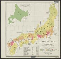
Japan: population densities by prefectures and province

北海道地貭略圖

surimono
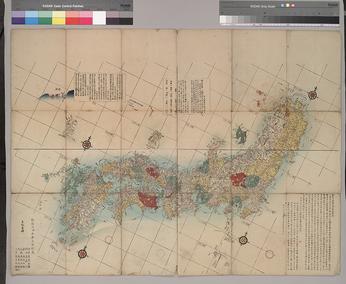
新刻日本輿地路程全圖
![Suirobu Hi [Kaizu]](https://stacks.stanford.edu/image/iiif/nm634np1065%2Fnm634np1065_0001/full/!200,200/0/default.jpg)
Suirobu Hi [Kaizu]

地球万国方図
![淡路国[南海道図]](https://rmda.kulib.kyoto-u.ac.jp/iiif/RB00020058/RB00020058_00001_0.ptif/full/200,/0/default.jpg)
淡路国[南海道図]

map from "Corea, the hermit nation. I. Ancient and mediæval history. II. Political and social Core...

Greece in the fifth century B.C

大日本帝國豫察中部地質圖

Karatsu, Saga Prefecture, Kyushu, Japan

Lustgarten des Shugakuin-Tempels, Kyoto

Japan road map, 1:1,000,000 / prepared under the direction of the Chief of Engineers, U.S. Army by the Army ...

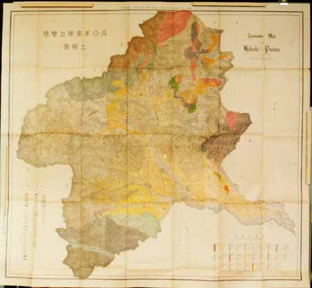
大日本帝國羽前全國羽後國飽海郡土性圖 = Agronomic map of Uzen-province and Akumi district of Ugo-province

北海道地質鑛産圖
Last Updated: 2020-04-16
Uploaded: 2021-07-27