
北海道地勢及鑛産圖 = Topographical map of Hokkaido with localities of useful minerals
- People
- Time
- Owner Organization


Geological map of Hokkaido = 北海道地質圖

Chart of Discoveries made in 1787, in the Seas of China and Tartary, by the Boussole and Astrolabe...

Zee-atlassen, wereldkaarten enz. >> "A new and correct outline chart intended for the use of...

Carte réduite de l'océan septentrional compris entre l'Asie et l'Amérique ... Par le Sr. Bellin ..

Japan. London atlas series. Stanford's Geographical Establishment. London : Edward Stanford, 26 & ...
Carte de L'Empire du Japon ..

Partie Septentrionale De L'Ocean Pacifique ou L'on Marque Les Decouvertes Et Les Routes De Mrs. De...

The world as known to the ancients

Chart of Discoveries made in 1787 In the Seas of China and Tartary between Manilla and Avateha by ...

Map of China and the surrounding regions
「紫式部 けんじかるた」」

Karta Morskykh Otkrytii Rossiiskimi Moreplavatelimi na Tikhom ... [transliterated from the Cyrilli...
![[Russian Map of Northeastern Asia, Japan, Korea, China, Alaska, etc.] ( Summary map of hydrographi...](https://stacks.stanford.edu/image/iiif/pj697kr2558%2F35405/full/!200,200/0/default.jpg)
[Russian Map of Northeastern Asia, Japan, Korea, China, Alaska, etc.] ( Summary map of hydrographi...

満州地質及鑛産分布圖 : 4

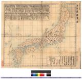
日本帝国鉱産図
Nokpong chŭngsŏ, 1819
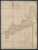
日本府県略図 : 日本府県略図
「紫式部けんじかるた」
「猿若三のふれん尽」 「井筒与三郎 沢村訥升」

Japan. (Boston: Published by Thomas & Andrews. 1812)

Carta General para las Navegaciones a la India Oriental por el Mar del Sur y el Grande Oceano que ...
Samarai, New Guinea

実業家所在案内 佐賀市街地図

Partie Septentrionale De L'Ocean Pacifique ou L'on Marque Les Decouvertes Et Les Routes De Mrs. De...
Last Updated: 2020-04-16
Uploaded: 2021-07-27