
Geological Survey of Japan : reconnaissance map, geology : div. 2
- People
- Time
- Owner Organization

Geological Survey of Japan : reconnaissance map, geology : div. 4

Geological Survey of Japan : reconnaissance map, geology : div. 1
GEOLOGICAL SURVEY OF JAPAN
Reconnaissance Soil Survey of Japan
![Imperial Geological Survey of Japan topographical map : Division I-[V]](https://collections.library.yale.edu/iiif/2/15828616/full/!200,200/0/default.jpg)
Imperial Geological Survey of Japan topographical map : Division I-[V]
Reconnaissance Soil Survey of Japan Shikoku
Reconnaissance Soil Survey of Japan Nagoya Area
Reconnaissance Soil Survey of Japan - Nagoya Area
Reconnaissance Soil Survey of Japan Hiroshima Area
Reconnaissance Soil Survey of Japan Hiroshima Area
Reconnaissance Soil Survey of Japan Kyoto Area
Reconnaissance Soil Survey of Japan Kyoto Area
Reconnaissance Soil Survey of Japan Nagoya Area
Reconnaissance Soil Survey of Japan Kanto Plain Area

Topographical map of the Japanese Empire, 1899 / Imperial Geological Survey of Japan ; drawn by T. Togawa an...
Relief map of southern Japan / prepared and reproduced in the United States Department of the Interior Geological Survey
Relief map of Southern Japan : special airfield relief map / prepared and reproduced in the United States Department of the Interior Geological Survey

GEOLOGICAL MAP COMMONWEALTH OF AUSTRALIA

The geology of Pennsylvania : a government survey

The M9.0 Great Tohoku Earthquake (northeast Honshu, Japan) of March 11, 2011 : earthquake summary map / U.S. Geological Survey
Chishitsu chōsa kenkyū hōkoku = Bulletin of the Geological Survey of Japan

GEOLOGICAL MAP OF THE STATE OF CALIFORNIA
Hokkaido, Japan : Special airfield relief map / prepared and reproduced in the United States Department of the Interior Geological Survey
Relief map of Northern Honshu : special airfield relief map / prepared and reproduced in the United States Department of the Interior Geological Survey

Politische Karte von China : Japan, Korea, China und der Mandschurei / herausgegeben von A. Scobel
Shinanozenzu

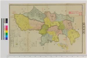
大日本帝國美作備前備中土性圖 = Agronomic map of Mimasaka Bizen and Bitchū provinces

大日本帝國豫察中部地形圖

大日本帝國羽前全國羽後國飽海郡土性圖 = Agronomic map of Uzen-province and Akumi district of Ugo-province

大日本帝国播磨但馬淡路全国摂津国西部丹波国西南部兵庫県管内土性図

佐賀県管内全図

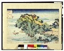
国輝 末広東海道五十三次 関
Stanford's map of the empires of China and Japan : with the adjacent parts of the Russian Empire, ...
Het Koninkrijk der Nederlanden / bew. door I. Dornseiffen ; get. door E. de Geest
夢の浮橋 第六十

Europa um 350 nach Christo
伊賀越道中双六

Omuta, Fukuoka Prefecture, Kyushu, Japan
![Settsu no Kuni meisho ōezu [cartographic material] : zen](https://stacks.stanford.edu/image/iiif/jy281rj3743%2Fjy281rj3743_0001/full/!200,200/0/default.jpg)
Settsu no Kuni meisho ōezu [cartographic material] : zen
![Generalis totius Imperii Russorum : novissima tabula magnam orbis terrarum partem â Polo Arctico usq[sic] ad mare Iaponicum et Chinæ Septentrionalis confinia exhibens : cum via Czaricae nuper Legationis ex urbe Moscua per universam Tartariam, ad magnu C](https://rmda.kulib.kyoto-u.ac.jp/iiif/RB00022903/RB00022903_00001_0.ptif/full/200,/0/default.jpg)
Generalis totius Imperii Russorum : novissima tabula magnam orbis terrarum partem â Polo Arctico usq[sic] ad mare Iaponicum et Chinæ Septentrionalis confinia exhibens : cum via Czaricae nuper Legationis ex urbe Moscua per universam Tartariam, ad magnu C
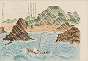
琉球八景_旬崖夕照

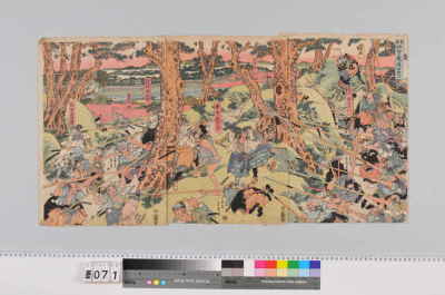
「伊賀ノ上野仇討ノ図」

Politisch-militärische Karte von Ost Asien zur Veranschaulichung der Kämpfe in China, Korea und Ja...

Carte du théâtre de la guerre russo-japonaise / Dressée par Emmanuel Barralier

大日本帝國豊後全國豊前國東南部土性圖

大阿蘇國立公園
![Suirobu Hi [Kaizu]](https://stacks.stanford.edu/image/iiif/nm634np1065%2Fnm634np1065_0001/full/!200,200/0/default.jpg)
Suirobu Hi [Kaizu]
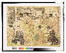
「高名美人見たて忠臣蔵」 「十二枚つゞき」「十一だんめ」
Last Updated: 2020-04-16
Uploaded: 2021-07-27