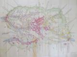
![[ローマ帝国道州図]](https://rmda.kulib.kyoto-u.ac.jp/iiif/RB00023933/RB00023933_00001_0.ptif/full/200,/0/default.jpg)
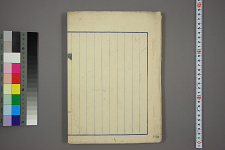
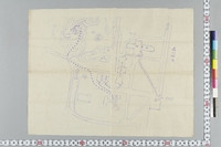
飛州国塩ノ道絵図
Takayamashi Kyoiku Iinkai
ADEAC: A System of Digitalization and Exhibition for Archive Collections
帝国図書館
National Institute of Japanese Literature
Collectors'Seals Database

九州帝国大学写真帖
Fukuoka City Museum
Fukuoka City Museum Collection Database

九州帝国大学農学部
Fukuoka Prefectural Library
ADEAC: A System of Digitalization and Exhibition for Archive Collections

九州帝国大学工学部
Fukuoka Prefectural Library
ADEAC: A System of Digitalization and Exhibition for Archive Collections
帝国図書館蔵
National Institute of Japanese Literature
Collectors'Seals Database
ローマ字ヲ国字トスベキ議
Waseda University Library
ARC Early Japanese Book Portal Database

九州鉄道線略図
Fukuoka City Museum
Fukuoka City Museum Collection Database

九州帝国大学医学部(2)
Fukuoka Prefectural Library
ADEAC: A System of Digitalization and Exhibition for Archive Collections

「帝国国会議事堂之図」
Tokyo Metropolitan Central Library
Tokyo Metropolitan Library Edo-Tokyo Digital Collections

信濃国縁絵図(信州・上州・甲州境の図)
ADEAC: A System of Digitalization and Exhibition for Archive Collections
帝国大学の地図
University of Tokyo Graduate School of Arts and Sciences / College of Liberal Arts
UTokyo Academic Archives Portal

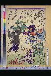
帝国大勝利之図
National Museum of Japanese History
IIIF Discovery in Japan
[帝国図書館月報]
NDL Digital Collections
NDL Digital Collections
[帝国図書館月報]
NDL Digital Collections
NDL Digital Collections
![[帝国大勝利之図]](http://www.rekihaku.ac.jp/GAZO/nishikie/shiryou/133731534603/071.jpg)
[帝国大勝利之図]
National Museum of Japanese History
ARC Ukiyo-e Portal Database
帝国図書館年報
NDL Digital Collections
NDL Digital Collections
帝国図書館年報
NDL Digital Collections
NDL Digital Collections
帝国図書館年報
NDL Digital Collections
NDL Digital Collections
帝国大学図書館
National Institute of Japanese Literature
Collectors'Seals Database

大和国帝陵絵図
National Diet Library, Japan
ARC Early Japanese Book Portal Database

日本帝国地質図
Kyushu University Collections
Kyushu University Collections

大日本帝国全図
Kyushu University Collections
Kyushu University Collections
.jpg)
「帝国議会衆議院之図」 「帝国議会衆議院之図」
Tokyo Metropolitan Central Library
ARC Ukiyo-e Portal Database

Europe in the reign of Theodoric. C.A.C. 500
Yoshida-South Library, Kyoto University
IIIF Discovery in Japan

Europa : end of 7th century. 695
Yoshida-South Library, Kyoto University
IIIF Discovery in Japan

Europe in the time of Charles the great 814
Yoshida-South Library, Kyoto University
IIIF Discovery in Japan

Greece in the fifth century B.C
Yoshida-South Library, Kyoto University
IIIF Discovery in Japan

An Improved Map of the United States By Shelton & Kensett
Stanford University Libraries
Stanford Libraries SearchWorks

Carte des Indes, de la Chine & des Iles de Sumatra, Java &c.
Stanford University Libraries
Stanford Libraries SearchWorks

「子供遊水合戦」
National Diet Library, Japan
ARC Ukiyo-e Portal Database

Europe showing the general direction of the Barbarian inroads on the fall of the Roman Empire
Yoshida-South Library, Kyoto University
IIIF Discovery in Japan
China and Japan
VU University Amsterdam Library
Europeana API

Baireikachougafu
National Diet Library, Japan
ARC Ukiyo-e Portal Database

Habu, Hiroshima Prefecture, Honshu, Japan
Stanford University Libraries
Stanford Libraries SearchWorks
「大一座葉唄の三会」
National Diet Library, Japan
ARC Ukiyo-e Portal Database
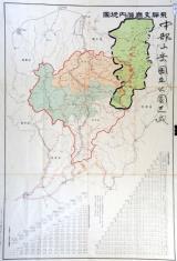
飛騨支庁管内地図(中部山岳国立公園区域図示 角竹記録)附 飛騨支庁管内里程表、各駅間粁数及三等運賃
Takayamashi Kyoiku Iinkai
ADEAC: A System of Digitalization and Exhibition for Archive Collections

Oshika hanto, Japan. (to accompany) Shomitsu Nippon chizu. (Atlas of Japan). Nippon Shoin. (Tokyo,...
Stanford University Libraries
Stanford Libraries SearchWorks

Isole Del Giappone e la Corea . . . 1797
Stanford University Libraries
Stanford Libraries SearchWorks

General map of China and adjacent regions, showing treaty ports and railways
Stanford University Libraries
Stanford Libraries SearchWorks
Last Updated: 2020-04-16
Uploaded: 2021-07-27