

National school board serie : No. 8 : India
Yoshida-South Library, Kyoto University
IIIF Discovery in Japan

National school board series : No. 4 : Asia
Yoshida-South Library, Kyoto University
IIIF Discovery in Japan
School Board - General
NDL Digital Collections
NDL Digital Collections
School Board - Wakayama
NDL Digital Collections
NDL Digital Collections
School Board - Shiga
NDL Digital Collections
NDL Digital Collections
School Board - Kyoto
NDL Digital Collections
NDL Digital Collections
Cabinet Board - 3rd National Diet
NDL Digital Collections
NDL Digital Collections
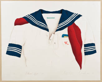
School Days - 2
Honolulu Museum of Art
Honolulu Museum of Art Collection
Records of the National Planning Board for Mobilization: Labor mobilisation plans (1941). Report No. 42a(1)(c), USSBS Index Section 2
NDL Digital Collections
NDL Digital Collections

National Highway No. 188
Museum of Fine Arts, Houston
Museum of Fine Arts, Houston
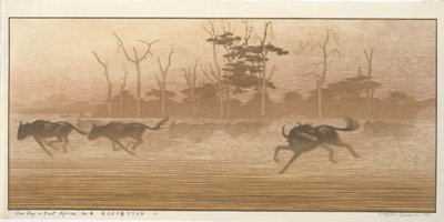
One Day in East Africa No. 4
Minneapolis Institute of Arts
Minneapolis Institute of Art API
Engineering school. Report No. 3v(13), USSBS Index Section 2
NDL Digital Collections
NDL Digital Collections
Divinity school. Report No. 3v(14), USSBS Index Section 2
NDL Digital Collections
NDL Digital Collections
Shiroyama school. Report No. 3v(21), USSBS Index Section 2
NDL Digital Collections
NDL Digital Collections
Inasa school. Report No. 3v(27), USSBS Index Section 2
NDL Digital Collections
NDL Digital Collections
Asahi school. Report No. 3v(28), USSBS Index Section 2
NDL Digital Collections
NDL Digital Collections
Landings in North Africa. Report No. 13-d(2), USSBS Index Section 6
NDL Digital Collections
NDL Digital Collections
![Comincia la serie delle battaglie e conquiste di Menphtah I [Seti I] nell' Asia e nell' Africa, rappresentat...](https://dp.la/thumb/0aab66d3b3c30518848ad8d9f141f90f)
Comincia la serie delle battaglie e conquiste di Menphtah I [Seti I] nell' Asia e nell' Africa, rappresentat...
General Research Division. The New York Public Library
DPLA API
![Comincia la serie delle battaglie e conquiste di Menphtah I [Seti I] nell' Asia e nell' Africa, rappresentat...](https://dp.la/thumb/93b0a7106870139f67253ce249b8e2a5)
Comincia la serie delle battaglie e conquiste di Menphtah I [Seti I] nell' Asia e nell' Africa, rappresentat...
General Research Division. The New York Public Library
DPLA API
Zenza grade school. Report No. 3v(18), USSBS Index Section 2
NDL Digital Collections
NDL Digital Collections
Tomachi grade school. Report No. 3v(39), USSBS Index Section 2
NDL Digital Collections
NDL Digital Collections
Chinzei high school. Report No. 3v(48), USSBS Index Section 2
NDL Digital Collections
NDL Digital Collections
Shinkoozen grade school. Report No. 3v(54), USSBS Index Section 2
NDL Digital Collections
NDL Digital Collections
Nagasaki Medical school. Report No. 3v(16), USSBS Index Section 2
NDL Digital Collections
NDL Digital Collections

Carte générale de l'Afrique, d'après les dernières découvertes
Yoshida-South Library, Kyoto University
IIIF Discovery in Japan

東亞大陸圖 : 二百五十万分一
Yoshida-South Library, Kyoto University
IIIF Discovery in Japan

Australia, Constructed & Engraved
Yoshida-South Library, Kyoto University
IIIF Discovery in Japan

General map of China and adjacent regions, showing treaty ports and railways
Stanford University Libraries
Stanford Libraries SearchWorks

「華頂山桜馬場風景」
C. V. Starr East Asian Library, University of California, Berkeley
ARC Ukiyo-e Portal Database

Amérique du Nord
Yoshida-South Library, Kyoto University
IIIF Discovery in Japan

General Railway Map of Japan and Manchuria : Showing lines open and under construction on March 31...
Stanford University Libraries
Stanford Libraries SearchWorks

Shintei shiku kaisei Tōkyō meisai zenzu
Stanford University Libraries
Stanford Libraries SearchWorks

Carte Physique & Politique. : No. 2 : l'Europe et du Bassin de la Méditerranée
Yoshida-South Library, Kyoto University
IIIF Discovery in Japan

北支事変方面概見図
Yoshida-South Library, Kyoto University
IIIF Discovery in Japan

An Improved Map of the United States By Shelton & Kensett
Stanford University Libraries
Stanford Libraries SearchWorks

Carte Des Indes et de la Chine Dressee sur plusieurs Rectifees par quelques Observations Par Guill...
Stanford University Libraries
Stanford Libraries SearchWorks
Last Updated: 2020-04-16
Uploaded: 2021-07-27