

Map of Chosen (Korea)
Yale University Library
Yale University Library Digital Collections
![Map of Chosen (Korea) [cartographic material].](https://stacks.stanford.edu/image/iiif/fx184cf7591%2Ffx184cf7591_0001/full/!200,200/0/default.jpg)
Map of Chosen (Korea) [cartographic material].
Stanford University Libraries
Stanford Libraries SearchWorks

朝鮮全圖
Yoshida-South Library, Kyoto University
IIIF Discovery in Japan

朝鮮ノ鳥採集ノート : 朝鮮ノ鳥採集 BiRD.S OF KOREA
Tomakomai City Central Library
ADEAC: A System of Digitalization and Exhibition for Archive Collections
Travelers' map of Japan, Chosen (Korea), Taiwan (Formosa) : with brief descriptions of the principal tourist points in Japan / Japanese Government Railways
National Library of Australia
Trove: National Library of Australia

Strategical map of part of Korea and Manchuria / prepared by the Second Division, General Staff (Military In...
Yale University Library
Yale University Library Digital Collections

Celebration of opening railway line from Seoul to Fusan, Chosen (Korea)
Library of Congress
Digital Collections, Library of Congress

Bartholomew's special Map of China, Japan and Korea
Bibliothèque nationale de France
Europeana API

Special war map of China, Korea, and Japan
Stanford University Libraries
Stanford Libraries SearchWorks
![[Russian Map of Northeastern Asia, Japan, Korea, China, Alaska, etc.] ( Summary map of hydrographi...](https://stacks.stanford.edu/image/iiif/pj697kr2558%2F35405/full/!200,200/0/default.jpg)
[Russian Map of Northeastern Asia, Japan, Korea, China, Alaska, etc.] ( Summary map of hydrographi...
Stanford University Libraries
Stanford Libraries SearchWorks

朝鮮ノ哺乳類日誌 : 朝鮮ノ哺乳類 THE MAMMALS OF KOREA
Tomakomai City Central Library
ADEAC: A System of Digitalization and Exhibition for Archive Collections

General map of the Government Railways in Japan
General Research Division. The New York Public Library
DPLA API
![[Taisho Japanese map of the world. Taisho Japanese map of Japan and Korea]. [9 insets].](https://stacks.stanford.edu/image/iiif/yj892bp5625%2F11670000/full/!200,200/0/default.jpg)
[Taisho Japanese map of the world. Taisho Japanese map of Japan and Korea]. [9 insets].
Stanford University Libraries
Stanford Libraries SearchWorks

The Naval Battle of Pungdo in Korea (Chosen Hoto kaisen no zu)
Art Institute of Chicago
Art Institute of Chicago API

The latest map of Manchuria, Korea, Formosa, and Saghalien
Stanford University Libraries
Stanford Libraries SearchWorks

Kyonghoe Hall, Kyongsong (Keijo Keikaro), from the series "Eight Views of Korea (Chosen hakkei)"
Art Institute of Chicago
Art Institute of Chicago API

Kyonghoe Hall, Kyongsong (Keijo Keikaro), from the series "Eight Views of Korea (Chosen hakkei)"
Art Institute of Chicago
Art Institute of Chicago API

Pulguk Temple, Kyongiu, from the series "Eight Views of Korea" (Chosen hakkei, Keishu Bukkokuji)
Art Institute of Chicago
Art Institute of Chicago API

朝鮮國全圖 : 附臺灣全島之圖
National Diet Library, Japan
ARC Early Japanese Book Portal Database

Rand, McNally & Co.'s 1904 war map of Russia and the continent of Asia
Yale University Library
Yale University Library Digital Collections

1904 war map of Japan, Korea, and China
Yale University Library
Yale University Library Digital Collections

1904 war map of Russia and the continent of Asia
Yale University Library
Yale University Library Digital Collections

The parasites of Popillia japonica in Japan and Chosen (Korea), and their introduction into the Un...
United States National Agricultural Library
Europeana API

General map of China and adjacent regions, showing treaty ports and railways
Stanford University Libraries
Stanford Libraries SearchWorks

大日本帝國中部地形圖
Yoshida-South Library, Kyoto University
IIIF Discovery in Japan
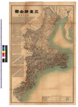
三重県全図 : 三重県全図
Iwase Bunko Libray
ADEAC: A System of Digitalization and Exhibition for Archive Collections

阿波国全図
Tokushima Prefectural Library
ADEAC: A System of Digitalization and Exhibition for Archive Collections

大日本帝國豫察中部地形圖
Yoshida-South Library, Kyoto University
IIIF Discovery in Japan

Kaetsunousanshuunozu
Imizu City Shinminato Museum
ADEAC: A System of Digitalization and Exhibition for Archive Collections
![[歴民カード_考古] 辻金具](https://khirin-i.rekihaku.ac.jp/iiif/nmjh_rekimin_a/22247141_02.tif/full/200,/0/default.jpg)
[歴民カード_考古] 辻金具
National Museum of Japanese History
IIIF Discovery in Japan
![安房国[東海道図]](https://rmda.kulib.kyoto-u.ac.jp/iiif/RB00020023/RB00020023_00001_0.ptif/full/200,/0/default.jpg)
安房国[東海道図]
Kyoto University Library
IIIF Discovery in Japan

surimono
British Museum
British Museum Collection
![遠江国[東海道図]](https://rmda.kulib.kyoto-u.ac.jp/iiif/RB00020017/RB00020017_00001_0.ptif/full/200,/0/default.jpg)
遠江国[東海道図]
Kyoto University Library
IIIF Discovery in Japan
Last Updated: 2020-04-16
Uploaded: 2021-07-27