

General map of China and adjacent regions, showing treaty ports and railways
Stanford University Libraries
Stanford Libraries SearchWorks

Pilgrims' map of Mount Fuji and surrounding temples
Freer and Sackler
DPLA API
![[Map of China]](https://collections.library.yale.edu/iiif/2/16189150/full/!200,200/0/default.jpg)
[Map of China]
Yale University Library
Yale University Library Digital Collections

Bartholomew's special Map of China, Japan and Korea
Bibliothèque nationale de France
Europeana API

Special war map of China, Korea, and Japan
Stanford University Libraries
Stanford Libraries SearchWorks
MAP, OF THE SEAT OF WAR BETWEEN CHINA AND JAPAN; (Auckland Star, 22 September 1894)
National Library of New Zealand
DigitalNZ New Zealand API

Charts, etc
Yale University Library
Yale University Library Digital Collections

A New Map of India & China From the latest Observations
Stanford University Libraries
Stanford Libraries SearchWorks
War map : Australia, China, Japan, and the South Pacific / Cyril Dillon
National Library of Australia
Trove: National Library of Australia

map from "Yedo and Peking. A narrative of a journey to the capitals of Japan and China. With notic...
British Library
Europeana API
Map - China, Central
NDL Digital Collections
NDL Digital Collections
"Daily Mail" map of the war in China / G. Philip & Son
National Library of Australia
Trove: National Library of Australia

Rand, McNally & Co.'s 1904 war map of Russia and the continent of Asia
Yale University Library
Yale University Library Digital Collections

1904 war map of Japan, Korea, and China
Yale University Library
Yale University Library Digital Collections

1904 war map of Russia and the continent of Asia
Yale University Library
Yale University Library Digital Collections

[Transport Map of Russia: 'Map of the routes of Steamships, Communication lines, Railways and Road...
Stanford University Libraries
Stanford Libraries SearchWorks

Map of the Empire of China and Japan. J.W. del. (engraved by) Stockley, Sc London, James Wyld, Cha...
Stanford University Libraries
Stanford Libraries SearchWorks
![Japan and adjacent regions of Asia and the Pacific Ocean [cartographic material] / compiled and drawn in the...](https://collections.library.yale.edu/iiif/2/15510875/full/!200,200/0/default.jpg)
Japan and adjacent regions of Asia and the Pacific Ocean [cartographic material] / compiled and drawn in the...
Yale University Library
Yale University Library Digital Collections
![Japan and adjacent regions of Asia and the Pacific Ocean [cartographic material] / compiled and drawn in the...](https://collections.library.yale.edu/iiif/2/15509964/full/!200,200/0/default.jpg)
Japan and adjacent regions of Asia and the Pacific Ocean [cartographic material] / compiled and drawn in the...
Yale University Library
Yale University Library Digital Collections
Report on the ichthyology of the seas of China and Japan.
国際日本文化研究センター
Catalogue of the pre-1900 printed books on Japan in European languages held by Nichibunken
China and the Chinese
Kansai University Open Research Center for Asian Studies
IIIF Discovery in Japan
Japan and adjacent regions of Asia and the Pacific Ocean / compiled and drawn in the Cartographic Section of the National Geographic Society
National Library of Australia
Trove: National Library of Australia
Court Exh. No. 620: The circumstances surrounding the conclusion of agreement between Japan and France concerning the advancement of the Japanese Army into French Indo-China
NDL Digital Collections
NDL Digital Collections
![[Taisho Japanese map of the world. Taisho Japanese map of Japan and Korea]. [9 insets].](https://stacks.stanford.edu/image/iiif/yj892bp5625%2F11670000/full/!200,200/0/default.jpg)
[Taisho Japanese map of the world. Taisho Japanese map of Japan and Korea]. [9 insets].
Stanford University Libraries
Stanford Libraries SearchWorks

Carte generale de l'Oceanie
Yoshida-South Library, Kyoto University
IIIF Discovery in Japan
明治事物起原 抄録 十五
Koriyama City Library
ADEAC: A System of Digitalization and Exhibition for Archive Collections

東亞大陸圖 : 二百五十万分一
Yoshida-South Library, Kyoto University
IIIF Discovery in Japan

Japan
Stanford University Libraries
Stanford Libraries SearchWorks

Carte Physique & Politique. : No. 2 : l'Europe et du Bassin de la Méditerranée
Yoshida-South Library, Kyoto University
IIIF Discovery in Japan

〔富士山三尊九尊来迎図〕
Mt.Fuji World Heritage Center, Shizuoka
ADEAC: A System of Digitalization and Exhibition for Archive Collections

日本本州南岸自東京海湾至和泉海
Yoshida-South Library, Kyoto University
IIIF Discovery in Japan

Kitsune no yome-iri (Object)
British Museum
British Museum Collection

「象頭山金比羅八景之内 満濃池遊鶴」
C. V. Starr East Asian Library, University of California, Berkeley
ARC Ukiyo-e Portal Database
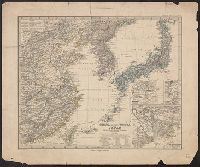
China (östlicheTheil), Korea und Japan im Massstab 1:7.500.000
Yale University Library
Yale University Library Digital Collections

China divided into its great provinces and the Isles of Japan by Samuel Dunn
Yale University Library
Yale University Library Digital Collections
Piece
Metropolitan Museum of Art
The Metropolitan Museum of Art Open Access CSV
Last Updated: 2020-04-16
Uploaded: 2021-07-27