日本・朝鮮図
- Owner Organization
日本・朝鮮図

朝鮮国図并中国、日本

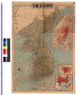
朝鮮国全図 : 朝鮮図
![裏日本と朝鮮 [(上)]/裏日本対北朝鮮貿易 (下)](https://da.lib.kobe-u.ac.jp/files/thumbnail/20000/0100339759/0100339759.jpg)
裏日本と朝鮮 [(上)]/裏日本対北朝鮮貿易 (下)
朝鮮平壌日本大勝利之図

COREA AND JAPAN(No.36)(朝鮮及日本図)
朝鮮国成歓日本大勝利之図
朝鮮国図

朝鮮図絵

朝鮮国図
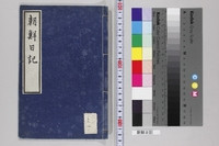
朝鮮日記

朝鮮八道之図 : 朝鮮八道之図

「朝鮮記聞大日本陸軍護営之図」

「朝鮮記聞大日本陸軍護営之図」

「朝鮮記聞大日本陸軍護営之図」

大日本軍艦朝鮮付近航海之図
朝鮮記聞大日本陸軍護営之図
朝鮮記聞大日本陸軍護営之図

「大日本軍艦朝鮮付近航海之図」
![[大日本軍艦朝鮮付近航海之図]](http://www.rekihaku.ac.jp/GAZO/nishikie/shiryou/133731534609/088.jpg)
[大日本軍艦朝鮮付近航海之図]
![[大日本軍艦朝鮮付近航海之図]](http://www.rekihaku.ac.jp/GAZO/nishikie/shiryou/133731534609/087.jpg)
[大日本軍艦朝鮮付近航海之図]

et des ROJAUMES de COREE ET DE JAPAN(朝鮮・日本図)
朝鮮地図 京城地図 : 朝鮮地図 京城地図

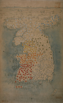
朝鮮八道図

住吉名所図絵写
Kantoukorokunochinohinagata、shinasadamesoumanomonbi

screen; painting

飛州大野郡高山城絵図(金森時代後期)

Charts, etc

佐賀県管内図

Il Regno Della China detto presentamente Catay e Mangin . . . 1682
Nijūgomanbun no ichi Papua-tō Sepikku-gawa ryūiki zu (Sheet 1)

佐賀県管内図

Kitsune no yome-iri (Object)

輿墜航海図

Laurie and Whittle's New Chart of the Indian and Pacific Oceans Between the Cape of Good Hope, New...
Woodblock print

「下加茂河合社糺川風景」

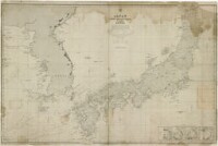
Asia, Japan and Korea : with the surrounding seas and the adjacent coastal region of China / published at Wa...
The Full Moon at the Time of the Imo Harvest
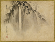
Waterfall

東洋歴史地図 : 元代彊域部

Map of China and the surrounding regions

Kanbara

「花園妙心寺」

Arai

Carte Des Indes et de la Chine Dressee sur plusieurs Relations particulieres Rectifees par quelque...
Last Updated: 2020-04-16
Uploaded: 2021-07-27