Map showing police districts of Tokyo and locations of headquarters of the guard rescue battalions (Keibitai). Report No. 4x, USSBS Index Section 2
Map showing locations of Tokyo water mains. Report No. 4q, USSBS Index Section 2
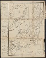
Map showing locations of fire battalion stations (headquarters), substations and auxiliary police and fire units. Report No. 5f, USSBS Index Section 2
Map of section of Tokyo showing locations and range of coverage of sirens connected to Eastern Army headquarters. Report No. 4h, USSBS Index Section 2
Chart showing locations of police offices. Report No. 10q(3), USSBS Index Section 2
Map of Tokyo zoning districts. Report No. 4v, USSBS Index Section 2
Map of Kyoto showing locations of fire stations. Report No. 6k, USSBS Index Section 2
Map of city of Kyoto showing locations of sirens. Report No. 6d, USSBS Index Section 2
Organization of guard rescue unit(Keibitai) showing chain of command. Report No. 11j(4), USSBS Index Section 2
Map showing locations of civilian observation posts in Kyoto Prefecture. Report No. 6e, USSBS Index Section 2
Map of Nagasaki showing administrative areas of various police stations. Report No. 5cc, USSBS Index Section 2
Map showing locations of static water supply and site of dam up. Report No. 5i, USSBS Index Section 2
Map of Kobe showing locations of 30 buildings on which protective measures were completed. Report No. 7x, USSBS Index Section 2
Map of harbor police. Report No. 8vv, USSBS Index Section 2
Map of the missionary districts of north Tokyo & Kyoto : under the jurisdiction of the Bishop of Tokyo 1895
Map of Kyoto showing distribution grid system and locations of hydrants with cut-out valves. Report No. 6m, USSBS Index Section 2
Map of Kobe showing fire-battalion districts, stations, and substations prior to March 1945. Report No. 7s, USSBS Index Section 2
Tokyo: Suburbs: Map showing suburbs. Report No. 14f(36)(h)4, USSBS Index Section 2
Map of Kobe showing fire-battalion districts and battalion stations and substations prior to 30 April 1945. Report No. 7r, USSBS Index Section 2

New Century map of Tokyo : with index
Private railways: Map showing private lines, tramways, and government railways by districts. Report No. 54k(1)(g), USSBS Index Section 2
Blueprint maps of the 12 Tokyo water districts. Report No. 4s, USSBS Index Section 2
Map- city of Tokyo. Report No. 12g(3), USSBS Index Section 2
Map showing disposition of Sho Group. Report No. 64c(45), USSBS Index Section 2
Map showing location of supply depots. Report No. 43e(2), USSBS Index Section 2
最終更新日:
登録日: 2020-12-17