Plan of the cable route between Japan and the mainland, and illustration of the method of raising it as expl...
- Time
- Owner Organization

Chinese and Japanese ports. (with) The mainland of Japan with the islands of Kiushiu & Shikoku. Ge...
![The plan of Juthja [Ayutthaya], the capital of Siam, and residence of the King](https://dp.la/thumb/9635a4a78f8a46e92f8d425589158e6b)
The plan of Juthja [Ayutthaya], the capital of Siam, and residence of the King
Tofua; Method of catching water and "Japanese" fishing floats
Naval and air demonstrations off the mainland of Japan just after the surrender. Top: Some of the 1000 carri...
![Plan of Jedo [Edo] , the capital of the Japanese Empire; coats of arms; the ensigns of honor and authority](https://dp.la/thumb/7801df68ac08c082275fb1676e69d083)
Plan of Jedo [Edo] , the capital of the Japanese Empire; coats of arms; the ensigns of honor and authority

On the guaranteed convergence of the Japanese zero-finding method

The emergence of new industries between path dependency and path plasticity : the case of Japan'...
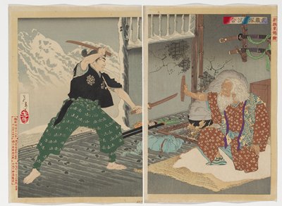
Picture of the Duel between Musashi and Tsukahara
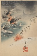
The destruction of Russ[i]an torpede [sic] destroyers by Japanese torpede destroyers at Port Arthur -- the illustration of the war between Japan and Russia (no. 5)
New Zealand troops in the transit area between Canea and Galatos, Crete, upon their arrival from mainland Gr...
Target Costing In the light of an ideological comparison between Japan and Sweden
The Furious Battle. Illustration of Japanese and Russian Torpedo Destroyers

Signature of the Tripartite Pact between Germany, Italy and Japan
![The destruction of Russ[i]an torpede [sic] destroyers by Japanese torpede destroyers at Port Arthur -- the illustration of the war between Japan and Russia (no. 5)](https://tile.loc.gov/storage-services/service/pnp/jpd/02500/02531_150px.jpg)
The destruction of Russ[i]an torpede [sic] destroyers by Japanese torpede destroyers at Port Arthur -- the illustration of the war between Japan and Russia (no. 5)

Conversation between father and son, Michael and Phil, about Michael's experience of a Japanese pr...
THE OUTLOOK IN THE EAST. "It is reported that Russia is fortifying 80 miles of coast between Port Arthur an...
Aerial view of the road between Castelfrentano and the Guardigrele crossroads, and the brickworks, Italy, Wo...
NZ engineers working on the route between Tahuna and Azizia, Libya, World War II - Photograph taken by H Pat...
A New Chart of the Indian and Pacific Oceans Between the Cape of Good Hope, New Holland, and Japan...

Laurie and Whittle's New Chart of the Indian and Pacific Oceans Between the Cape of Good Hope, New...

Laurie and Whittle's New Chart of the Indian and Pacific Oceans Between the Cape of Good Hope, New...

Fifty-three Stations of the Tokaido: Between Tsuchiyama and Minakuchi--Matsuno-o/Matsuomaru
![Russian Empire [with] Chart of the Communication Between The Archipelago And Black Sea](https://stacks.stanford.edu/image/iiif/bk956jy9388%2F18960/full/!200,200/0/default.jpg)
Russian Empire [with] Chart of the Communication Between The Archipelago And Black Sea

Illustration which identifies and names the acupuncture points in some of the fourteen bodily trac...
Last Updated:
Uploaded: 2020-12-17