

位記(叙従三位)
Fukuoka City Museum
Fukuoka City Museum Collection Database
位記(叙従三位)
NDL Digital Collections
NDL Digital Collections
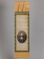
従三位大村公画像
ADEAC: A System of Digitalization and Exhibition for Archive Collections
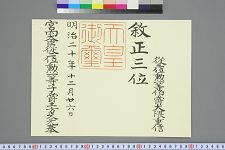
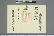
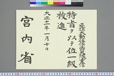
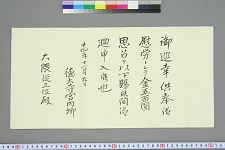
叙正三位位記従三位勲一等伯爵大隈重信
Waseda University Library
ARC Early Japanese Book Portal Database

条里のわけ方
Fukuoka City Museum
Fukuoka City Museum Collection Database

「都名所」 「三条大橋」
Art Institute of Chicago
ARC Ukiyo-e Portal Database
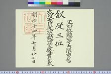
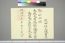
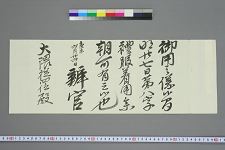
叙従三位位記正四位勲一等大隈重信
Waseda University Library
ARC Early Japanese Book Portal Database
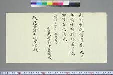
叙正三位位記添状従三位勲一等伯爵大隈重信
Waseda University Library
ARC Early Japanese Book Portal Database

「都三条大橋眺望図」
C. V. Starr East Asian Library, University of California, Berkeley
ARC Ukiyo-e Portal Database

「都三条大橋眺望図」
C. V. Starr East Asian Library, University of California, Berkeley
ARC Ukiyo-e Portal Database

五条大橋
NHK Archives
Michi-shiru: Japan Seasonal Journey
叙従三位位記添状正四位勲一等大隈重信
Waseda University Library
ARC Early Japanese Book Portal Database
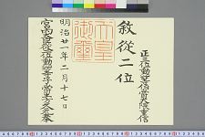
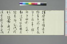
叙従二位位記正三位勲一等伯爵大隈重信
Waseda University Library
ARC Early Japanese Book Portal Database
叙正四位位記従四位大隈重信
Waseda University Library
ARC Early Japanese Book Portal Database
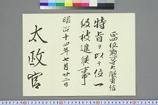
叙従一位位記正二位大勲位侯爵大隈重信
Waseda University Library
ARC Early Japanese Book Portal Database

絵葉書「京都」三条大橋
Fukuoka City Museum
Fukuoka City Museum Collection Database
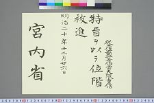
御召状大隈従四位
Waseda University Library
ARC Early Japanese Book Portal Database
叙従一位位記添状正二位大勲位侯爵大隈重信
Waseda University Library
ARC Early Japanese Book Portal Database
吉井友実書翰従三位大隈重信
Waseda University Library
ARC Early Japanese Book Portal Database
御召状従三位勲一等大隈重信
Waseda University Library
ARC Early Japanese Book Portal Database
金五百円下賜通知大隈従三位
Waseda University Library
ARC Early Japanese Book Portal Database

「日本橋より江戸附近里程」
Tokyo Metropolitan Central Library
Tokyo Metropolitan Library Edo-Tokyo Digital Collections
従一位大勲位侯爵大隈公墓誌拓本
Waseda University Library
ARC Early Japanese Book Portal Database

「東海道五十三駅」 「京三条大橋」
National Diet Library, Japan
ARC Ukiyo-e Portal Database
![[Taiwan and the Coast of Fujian and Guandong, China] Kaart van de Chineesche Kust en van Formosa v...](https://stacks.stanford.edu/image/iiif/zy510ks0323%2F34567/full/!200,200/0/default.jpg)
[Taiwan and the Coast of Fujian and Guandong, China] Kaart van de Chineesche Kust en van Formosa v...
Stanford University Libraries
Stanford Libraries SearchWorks

Partie Septentrionale De L'Ocean Pacifique ou L'on Marque Les Decouvertes Et Les Routes De Mrs. De...
Stanford University Libraries
Stanford Libraries SearchWorks

Skizze des weges von Tokio nach Yumotto (Nikko Berge) nach eigenen Aufzeichnungen / von E. Knippin...
Bibliothèque nationale de France
Europeana API
![[Japan] (Published in Manila!)](https://stacks.stanford.edu/image/iiif/gv355sq3352%2F37869hs/full/!200,200/0/default.jpg)
[Japan] (Published in Manila!)
Stanford University Libraries
Stanford Libraries SearchWorks
![America Bay [cartographic material]](https://stacks.stanford.edu/image/iiif/nj035cf2832%2Fnj035cf2832_00_0001/full/!200,200/0/default.jpg)
America Bay [cartographic material]
Stanford University Libraries
Stanford Libraries SearchWorks

The Islands of Japan, by James Wyld,..
Bibliothèque nationale de France
Europeana API

Partie Septentrionale De L'Ocean Pacifique ou L'on Marque Les Decouvertes Et Les Routes De Mrs. De...
Stanford University Libraries
Stanford Libraries SearchWorks
Jūmanbun no ichi Nyū Airurando-tō
National Library of Australia
Trove: National Library of Australia
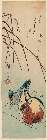
「(枯芦に鴛鴦(おしどり))」
Museum of Fine Arts, Boston
ARC Ukiyo-e Portal Database
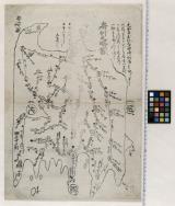
房州之畧図
Funabashi-shi Western Library
ADEAC: A System of Digitalization and Exhibition for Archive Collections
![[Carte de Lieou Kieou] / [par Shihei Hayashi]](https://api.europeana.eu/api/v2/thumbnail-by-url.json?uri=http%3A%2F%2Fgallica.bnf.fr%2Fark%3A%2F12148%2Fbtv1b55000388q.thumbnail.jpg&type=IMAGE)
[Carte de Lieou Kieou] / [par Shihei Hayashi]
Bibliothèque nationale de France
Europeana API
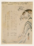
Surimono
Brooklyn Museum
Brooklyn Museum API
Last Updated: 2019-07-07
Uploaded: 2023-04-03