
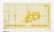
〔御屋敷図〕
ADEAC: A System of Digitalization and Exhibition for Archive Collections
御屋敷図
ADEAC: A System of Digitalization and Exhibition for Archive Collections

御敷地小屋場絵図
Kyoto University Library
IIIF Discovery in Japan

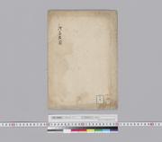
御薗手代屋敷御添地手代屋敷図 : 名古屋切図
Iwase Bunko Libray
ADEAC: A System of Digitalization and Exhibition for Archive Collections
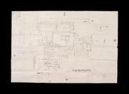
浅草御屋敷御殿地絵図
ADEAC: A System of Digitalization and Exhibition for Archive Collections

御定番御役屋敷并組屋敷共地所絵図
Kyoto University Library
IIIF Discovery in Japan

奥御右筆御役屋敷地絵図
Kyoto University Library
IIIF Discovery in Japan

皇室御料地敷地図/神戸御用邸
Tokyo Metropolitan Central Library
Tokyo Metropolitan Library Edo-Tokyo Digital Collections

皇室御料地敷地図/横浜御用邸
Tokyo Metropolitan Central Library
Tokyo Metropolitan Library Edo-Tokyo Digital Collections

用屋敷地守 3巻
National Diet Library, Japan
ARC Early Japanese Book Portal Database

用屋敷地守 3巻
National Diet Library, Japan
ARC Early Japanese Book Portal Database

用屋敷地守 3巻
National Diet Library, Japan
ARC Early Japanese Book Portal Database

用屋敷地守 3巻
National Diet Library, Japan
ARC Early Japanese Book Portal Database

御家中屋敷地絵図 中巻
Digital Archive Fukui
Digital Archive Fukui

御家中屋敷地絵図 下巻
Digital Archive Fukui
Digital Archive Fukui

皇室御料地敷地図/渋谷第二御用地
Tokyo Metropolitan Central Library
Tokyo Metropolitan Library Edo-Tokyo Digital Collections

新御屋敷絵図
Hiroshima City Central Library
ADEAC: A System of Digitalization and Exhibition for Archive Collections

屋敷地概略図
Digital Archive Fukui
Digital Archive Fukui

(土蔵、屋敷間数、敷地図)
Digital Archive Fukui
Digital Archive Fukui
![[屋敷地]](https://www.bunka.pref.mie.lg.jp/Miebunka/rest/media/S?cls=muse_col22&pkey=0000002768)
[屋敷地]
三重県環境生活部文化振興課
Specified Historical Public Records and Archives, Mie
![[屋敷地]](https://www.bunka.pref.mie.lg.jp/Miebunka/rest/media/S?cls=muse_col22&pkey=0000002769)
[屋敷地]
三重県環境生活部文化振興課
Specified Historical Public Records and Archives, Mie
![[屋敷地]](https://www.bunka.pref.mie.lg.jp/Miebunka/rest/media/S?cls=muse_col22&pkey=0000002770)
[屋敷地]
三重県環境生活部文化振興課
Specified Historical Public Records and Archives, Mie
![[屋敷地]](https://www.bunka.pref.mie.lg.jp/Miebunka/rest/media/S?cls=muse_col22&pkey=0000002771)
[屋敷地]
三重県環境生活部文化振興課
Specified Historical Public Records and Archives, Mie

皇室御料地敷地図/宝田町三番地御用地
Tokyo Metropolitan Central Library
Tokyo Metropolitan Library Edo-Tokyo Digital Collections

A New Chart of The Pacific Ocean, Exhibiting The Western Coast of America from Cape Horn to Beerin...
Stanford University Libraries
Stanford Libraries SearchWorks

Laurie and Whittle's New Chart of the Indian and Pacific Oceans Between the Cape of Good Hope, New...
Stanford University Libraries
Stanford Libraries SearchWorks

「西国三十三所順拝地図」
Tokyo Metropolitan Central Library
ARC Ukiyo-e Portal Database

「上州草津温泉之図」
Tokyo Metropolitan Central Library
ARC Ukiyo-e Portal Database

「〔地図〕」
Tokyo Metropolitan Central Library
ARC Ukiyo-e Portal Database

A New Chart of The Pacific Ocean, Exhibiting The Western Coast of America, From Cape Horn To Beeri...
Stanford University Libraries
Stanford Libraries SearchWorks

「秋葉山」
C. V. Starr East Asian Library, University of California, Berkeley
ARC Ukiyo-e Portal Database
![「[桃太郎]」 「〔疱瘡に関する絵〕」](https://archive.library.metro.tokyo.lg.jp/da/download/?id=0000000003-00224601&size=thumb&type=image&file=/浮世絵/778-C017.jpg)
「[桃太郎]」 「〔疱瘡に関する絵〕」
Tokyo Metropolitan Central Library
ARC Ukiyo-e Portal Database
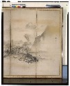
山水図屏風
Tokyo National Museum
ARC Ukiyo-e Portal Database

出羽一国御絵図
Sakata City Koukyuu-bunko Museum
ADEAC: A System of Digitalization and Exhibition for Archive Collections

「出羽国置賜郡米沢小野川温泉図」
Tokyo Metropolitan Central Library
ARC Ukiyo-e Portal Database

「根上松」
C. V. Starr East Asian Library, University of California, Berkeley
ARC Ukiyo-e Portal Database
Last Updated: 2020-07-28
Uploaded: 2023-04-03