
作例類語 六 : 作例類語
ADEAC: A System of Digitalization and Exhibition for Archive Collections
作例類語 九 : 作例類語
ADEAC: A System of Digitalization and Exhibition for Archive Collections
作例類語 三 : 作例類語
ADEAC: A System of Digitalization and Exhibition for Archive Collections
作例類語 ニ : 作例類語
ADEAC: A System of Digitalization and Exhibition for Archive Collections

作例類語 一 : 作例類語
ADEAC: A System of Digitalization and Exhibition for Archive Collections

作例類語 八 : 作例類語
ADEAC: A System of Digitalization and Exhibition for Archive Collections

掇話類
National Institute of Japanese Literature
IIIF Discovery in Japan
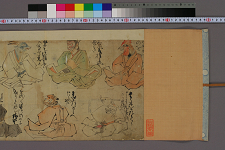
十二類絵詞
Waseda University Library
ARC Early Japanese Book Portal Database

作例類語 十七 : 作例類語
ADEAC: A System of Digitalization and Exhibition for Archive Collections
作例類語 十六 : 作例類語
ADEAC: A System of Digitalization and Exhibition for Archive Collections
作例類語 十一 : 作例類語
ADEAC: A System of Digitalization and Exhibition for Archive Collections
作例類語 十五 : 作例類語
ADEAC: A System of Digitalization and Exhibition for Archive Collections
作例類語 十四 : 作例類語
ADEAC: A System of Digitalization and Exhibition for Archive Collections
作例類語 十九 : 作例類語
ADEAC: A System of Digitalization and Exhibition for Archive Collections

作例類語 十二 : 作例類語
ADEAC: A System of Digitalization and Exhibition for Archive Collections
作例類語 六十 : 作例類語
ADEAC: A System of Digitalization and Exhibition for Archive Collections
作例類語 四十四 : 作例類語
ADEAC: A System of Digitalization and Exhibition for Archive Collections

作例類語 二十八 : 作例類語
ADEAC: A System of Digitalization and Exhibition for Archive Collections
作例類語 三十三 : 作例類語
ADEAC: A System of Digitalization and Exhibition for Archive Collections

作例類語 三十六 : 作例類語
ADEAC: A System of Digitalization and Exhibition for Archive Collections
作例類語 四十二 : 作例類語
ADEAC: A System of Digitalization and Exhibition for Archive Collections

作例類語 四十九 : 作例類語
ADEAC: A System of Digitalization and Exhibition for Archive Collections

作例類語 二十六 : 作例類語
ADEAC: A System of Digitalization and Exhibition for Archive Collections

作例類語 二十九 : 作例類語
ADEAC: A System of Digitalization and Exhibition for Archive Collections

「文久改正年数早見」
Tokyo Metropolitan Central Library
ARC Ukiyo-e Portal Database

筑摩県統計一覧表
Takayamashi Kyoiku Iinkai
ADEAC: A System of Digitalization and Exhibition for Archive Collections

「西国十六番清水寺(一枚物)」
Tokyo Metropolitan Central Library
ARC Ukiyo-e Portal Database

「卯の春四方一覧」
C. V. Starr East Asian Library, University of California, Berkeley
ARC Ukiyo-e Portal Database
瀟湘八景図屏風
Tokyo National Museum
ARC Ukiyo-e Portal Database

A new & correct chart of the Indian sea from Cabo Bonea Esperanca to Japan : according to Mr Edwar...
Bibliothèque nationale de France
Europeana API
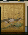
芦雁図
Tokyo National Museum
ARC Ukiyo-e Portal Database
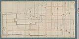
吉田城内之図
Toyohashi City Library
ADEAC: A System of Digitalization and Exhibition for Archive Collections
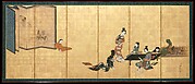
Parody of the Four Accomplishments
Metropolitan Museum of Art
The Metropolitan Museum of Art Open Access CSV
![[3 maps of Leyte Island, Philippines, in Japanese.]](https://collections.library.yale.edu/iiif/2/15251299/full/!200,200/0/default.jpg)
[3 maps of Leyte Island, Philippines, in Japanese.]
Yale University Library
Yale University Library Digital Collections
A chart of the eastermost part of the East Indies with all the adjacent islands from Cape Comorin to Iapan / by Iohn Seller, Hydrographer to the King
National Library of Australia
Trove: National Library of Australia
Last Updated: 2019-07-07
Uploaded: 2023-04-03