

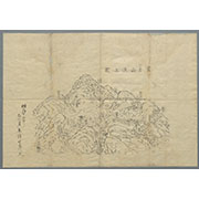
富士須走口駿河登山道案内
国際日本文化研究センター
IIIF Discovery in Japan

富士登山 富士山 須走登山口
Mt.Fuji World Heritage Center, Shizuoka
ADEAC: A System of Digitalization and Exhibition for Archive Collections

須走登山口ノ富士
Mt.Fuji World Heritage Center, Shizuoka
ADEAC: A System of Digitalization and Exhibition for Archive Collections

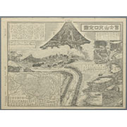
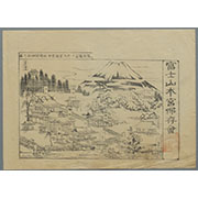
冨士登山口全図
Mt.Fuji World Heritage Center, Shizuoka
ADEAC: A System of Digitalization and Exhibition for Archive Collections

富士登山 富士山 須走口六合目
Mt.Fuji World Heritage Center, Shizuoka
ADEAC: A System of Digitalization and Exhibition for Archive Collections

「〔富士登山案内図〕」
Tokyo Metropolitan Central Library
ARC Ukiyo-e Portal Database

〔富士登山案内図〕
Tokyo Metropolitan Central Library
Tokyo Metropolitan Library Edo-Tokyo Digital Collections

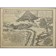
富士登山案内図
Mt.Fuji World Heritage Center, Shizuoka
ADEAC: A System of Digitalization and Exhibition for Archive Collections

富士登山案内図
Mt.Fuji World Heritage Center, Shizuoka
ADEAC: A System of Digitalization and Exhibition for Archive Collections

富士山須走口 馬返
Mt.Fuji World Heritage Center, Shizuoka
ADEAC: A System of Digitalization and Exhibition for Archive Collections

登冨士山記
Ibaraki University Library
茨城大学デジタルコレクション
冨士山北口全図
Mt.Fuji World Heritage Center, Shizuoka
ADEAC: A System of Digitalization and Exhibition for Archive Collections
冨士山北口全図
Mt.Fuji World Heritage Center, Shizuoka
ADEAC: A System of Digitalization and Exhibition for Archive Collections

富士登山吉田口 砂走り
Mt.Fuji World Heritage Center, Shizuoka
ADEAC: A System of Digitalization and Exhibition for Archive Collections

富士登山 富士山 須走口六合目より頂上を望む
Mt.Fuji World Heritage Center, Shizuoka
ADEAC: A System of Digitalization and Exhibition for Archive Collections
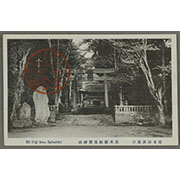
富士須走口 須走県社浅間神社
Mt.Fuji World Heritage Center, Shizuoka
ADEAC: A System of Digitalization and Exhibition for Archive Collections

富士須走口 六合目
Mt.Fuji World Heritage Center, Shizuoka
ADEAC: A System of Digitalization and Exhibition for Archive Collections

富士須走口 三合目
Mt.Fuji World Heritage Center, Shizuoka
ADEAC: A System of Digitalization and Exhibition for Archive Collections
富士須走口 五合目
Mt.Fuji World Heritage Center, Shizuoka
ADEAC: A System of Digitalization and Exhibition for Archive Collections
富士山頂上図(表口、須山口)
Mt.Fuji World Heritage Center, Shizuoka
ADEAC: A System of Digitalization and Exhibition for Archive Collections

富士東口須走浅間神社表門
Mt.Fuji World Heritage Center, Shizuoka
ADEAC: A System of Digitalization and Exhibition for Archive Collections

富士東口須走浅間神社楼門
Mt.Fuji World Heritage Center, Shizuoka
ADEAC: A System of Digitalization and Exhibition for Archive Collections

富士山須走口 一合目 二合目
Mt.Fuji World Heritage Center, Shizuoka
ADEAC: A System of Digitalization and Exhibition for Archive Collections

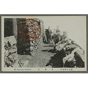
富士山須走口 七合五勺石室
Mt.Fuji World Heritage Center, Shizuoka
ADEAC: A System of Digitalization and Exhibition for Archive Collections
Pas-caert van't Oostelyckste deel van Oost Indien : met alle de Eylanden daer onder gelegen, van Cabo Comorin tot aen Japan / by Hendrick Doncker Boekverkooper en Graadbooghmaacker Inde Nieuwbrughsteegh
National Library of Australia
Trove: National Library of Australia
駿河国富士郡大宮国幣中社浅間神社之図
Mt.Fuji World Heritage Center, Shizuoka
ADEAC: A System of Digitalization and Exhibition for Archive Collections

「大仏耳塚」
C. V. Starr East Asian Library, University of California, Berkeley
ARC Ukiyo-e Portal Database

Auckland Harbour
Stanford University Libraries
Stanford Libraries SearchWorks

「上州草津温泉之全図」
Tokyo Metropolitan Central Library
ARC Ukiyo-e Portal Database

「安房国鋸山日本寺図」
Tokyo Metropolitan Central Library
ARC Ukiyo-e Portal Database
禽虫之図
Tokyo National Museum
ARC Ukiyo-e Portal Database
Asia and its several islands and regions : according to their most approved divisions with Captain Cooks new discoveries / by Thomas Kitchin, Hydrographer to His Majesty
National Library of Australia
Trove: National Library of Australia

「上州草津温泉之全図」
Tokyo Metropolitan Central Library
ARC Ukiyo-e Portal Database

「下野国塩谷郡塩原温泉之図」
Tokyo Metropolitan Central Library
ARC Ukiyo-e Portal Database

「〔箱根絵図〕」
Tokyo Metropolitan Central Library
ARC Ukiyo-e Portal Database
Last Updated: 2025-07-15
Uploaded: 2025-07-16