
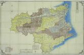
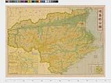
徳島県明細全図
Tokushima Prefectural Library
ADEAC: A System of Digitalization and Exhibition for Archive Collections
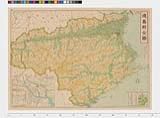
徳島県(地図)
Tokushima Prefectural Archives
ADEAC: A System of Digitalization and Exhibition for Archive Collections

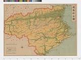
徳島県地図
Tokushima Prefectural Archives
ADEAC: A System of Digitalization and Exhibition for Archive Collections

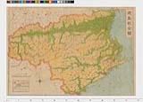
徳島県(地図)
Tokushima Prefectural Archives
ADEAC: A System of Digitalization and Exhibition for Archive Collections

徳島縣明細地圖
Kochi Prefectural Library
OTEPIA Kochi Library collection search
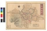
徳島市街明細図
Tokushima Prefectural Archives
ADEAC: A System of Digitalization and Exhibition for Archive Collections

徳島県地図全
Tokushima Prefectural Archives
ADEAC: A System of Digitalization and Exhibition for Archive Collections
徳島県管内地図
Tokushima Prefectural Archives
ADEAC: A System of Digitalization and Exhibition for Archive Collections

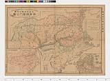
日本交通分県地図 其八 徳島県 : 徳島県図
Iwase Bunko Libray
ADEAC: A System of Digitalization and Exhibition for Archive Collections
帝国府県地図 徳島県
Tokushima Prefectural Archives
ADEAC: A System of Digitalization and Exhibition for Archive Collections
帝国府県地図 徳島県
Tokushima Prefectural Archives
ADEAC: A System of Digitalization and Exhibition for Archive Collections

徳島県災害全地図
Tokushima Prefectural Archives
ADEAC: A System of Digitalization and Exhibition for Archive Collections
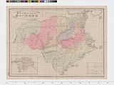
徳島県日本新分県地図
Tokushima Prefectural Archives
ADEAC: A System of Digitalization and Exhibition for Archive Collections
日本新分県地図 徳島県
Tokushima Prefectural Archives
ADEAC: A System of Digitalization and Exhibition for Archive Collections

大日本商工地図之内徳島県徳島・小松島市街地図
Tokushima Prefectural Archives
ADEAC: A System of Digitalization and Exhibition for Archive Collections

大日本分県地図 最新徳島県
Tokushima Prefectural Archives
ADEAC: A System of Digitalization and Exhibition for Archive Collections

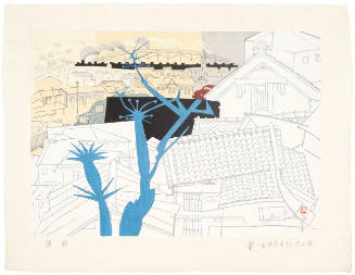
徳島県徳島市
NHK Archives
Michi-shiru: Japan Seasonal Journey

徳島市街地図
Tokushima Prefectural Library
ADEAC: A System of Digitalization and Exhibition for Archive Collections
大徳島市地図
ADEAC: A System of Digitalization and Exhibition for Archive Collections
徳島県管内全図
ADEAC: A System of Digitalization and Exhibition for Archive Collections
徳島県管内全図
Tokushima Prefectural Archives
ADEAC: A System of Digitalization and Exhibition for Archive Collections

徳島県管内図 全
Tokushima Prefectural Archives
ADEAC: A System of Digitalization and Exhibition for Archive Collections

路線価図 : 徳島県
NDL Digital Collections
NDL Digital Collections

路線価図 : 徳島県
NDL Digital Collections
NDL Digital Collections
Acer mono Maxim
University of Vienna, Institute for Botany - Herbarium WU
Europeana API
Lamium album L
University of Vienna, Institute for Botany - Herbarium WU
Europeana API
三重県全図 : 三重県全図
Iwase Bunko Libray
ADEAC: A System of Digitalization and Exhibition for Archive Collections

surimono
British Museum
British Museum Collection

surimono
British Museum
British Museum Collection

阿波国全図
Tokushima Prefectural Library
ADEAC: A System of Digitalization and Exhibition for Archive Collections

(新刻)日本與地路程全図
Kyoto University Library
IIIF Discovery in Japan

水戸市全地図
水戸市立中央図書館
ADEAC: A System of Digitalization and Exhibition for Archive Collections

日本本州北西岸能登七尾湾= Japan Honshū, N. W. coast, Nanao Bay : north bay from survey of Lieutt. K. Kimotski, I. J. N. 12th. Year of Meiji (1879), South Bay, West Bay and the Soundings at outer part of the Bays from survey of commr. K. Isono
Yoshida-South Library, Kyoto University
IIIF Discovery in Japan

阿波郡伊沢村分間絵図
Tokushima Prefectural Library
ADEAC: A System of Digitalization and Exhibition for Archive Collections
Hepatica nobilis Schreb
University of Vienna, Institute for Botany - Herbarium WU
Europeana API

Maebashi, Gumma Prefecture, Honshu, Japan
Stanford University Libraries
Stanford Libraries SearchWorks
Hamamatsu: Factories in the Morning (Hamamatsu Asa no Kōjō), series The Fifty-three Stations of the Tōkaidō
Honolulu Museum of Art
Honolulu Museum of Art Collection

岐阜県管内図
Takayamashi Kyoiku Iinkai
ADEAC: A System of Digitalization and Exhibition for Archive Collections
Last Updated: 2025-06-03
Uploaded: 2025-06-04