Asia with the islands adioyning described, the atire of the people, & townes of importance, all of them newly augmented
- People
- Time
- Owner Organization

A chart of the easternmost part of the East Indies with all the adjacent islands from Cape Comorin...
Royal Museums Greenwich
Europeana API
A new plaine and exact map of Asia / described by N.I. Vischer and rendered into English with habits of the countries and manner of the chiefe citties
National Library of Australia
Trove: National Library of Australia
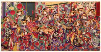
Merrymaking with All of the Flowers of the Yoshiwara Brothel District
Honolulu Museum of Art
Honolulu Museum of Art Collection

Chinese and Japanese ports. (with) The mainland of Japan with the islands of Kiushiu & Shikoku. Ge...
Stanford University Libraries
Stanford Libraries SearchWorks
Asia and its islands according to Danville : divided into empires, kingdoms, states, regions &ca. with the European possessions and settlements in the East Indies and an exact delineation of all the discoveries made in the Eastern parts by the English under Captn. Cook
State Library of New South Wales
Trove: National Library of Australia

A Map of Marco Polo's Voyages & Travels in the 13th Century trhough a great Part of Asia, all Tart...
Stanford University Libraries
Stanford Libraries SearchWorks

A chart of the eastermost part of the East Indies with all the adjacent islands from Cape Comorin to Iapan / by Iohn Seller, Hydrographer to the King ; F. Lamb Sculp
State Library of New South Wales
Trove: National Library of Australia
Asia with its islands and different regions : according to their modern divisions ; also the discoveries made by Capt. Cook
National Library of Australia
Trove: National Library of Australia

A chart of the tradeing part of the East Indies and China, with the adjacent islands, from Surrat ...
Royal Museums Greenwich
Europeana API
A chart of the eastermost part of the East Indies with all the adjacent islands from Cape Comorin to Iapan / by Iohn Seller, Hydrographer to the King
National Library of Australia
Trove: National Library of Australia

A voyage of discovery to the North Pacific Ocean in which the coast of Asia, from the lat. of 35@ ...
Canadiana.org
Europeana API
A voyage of discovery to the North Pacific Ocean in which the coast of Asia, from the lat. of 35@ ...
Canadiana.org
Europeana API

Map of Asia showing its Gt. Political Divisions, and, also, the Various routes of travel between L...
Stanford University Libraries
Stanford Libraries SearchWorks
WAR IN THE EAST This map shows Malaya and the Philippine Islands and the principal scenes of the Japanese of...
National Library of New Zealand
DigitalNZ New Zealand API

Charts, etc
Yale University Library
Yale University Library Digital Collections

A New Map of Great Tartary and China, with the adjoyning Parts of Asia, Taken from Mr. De Fer's Ma...
Stanford University Libraries
Stanford Libraries SearchWorks

A New Map of Great Tartary and China, with the adjoyning Parts of Asia, Taken from Mr. De Fer's Ma...
Stanford University Libraries
Stanford Libraries SearchWorks

A New Map of Great Tartary and China, with the adjoyning Parts of Asia, Taken from Mr. De Fer's Ma...
Stanford University Libraries
Stanford Libraries SearchWorks

Equipped with all the latest devices for war at sea, H. M. N. Z. S. Achilles, whose role in the Battle of th...
Auckland Libraries
DigitalNZ New Zealand API
Asia and its several islands and regions : according to their most approved divisions with Captain Cooks new discoveries / by Thomas Kitchin, Hydrographer to His Majesty
National Library of Australia
Trove: National Library of Australia
A new chart of the Pacific Ocean : exhibiting the western coast of America, from Cape Horn to Beerings Strait, the eastern shores of Asia including Japan, China and Australia and all the numerous islands and known dangers situated in Polynesia and Australasia / correctly drawn and regulated according to the most approved and modern surveys and astronomical observations by J.W. Norie
State Library of New South Wales
Trove: National Library of Australia

A Doctor who Helps People with their Lives Taking a Woman's Pulse, from the series Moral Lessons through Pictures of Good and Evil (Kyōkun zenaku zukai)
Philadelphia Museum of Art
Philadelphia Museum of Art collection

Heitia Hiha explains the significance of meeting house carvings to Tokio Hasegawa
MTG Hawke's Bay
DigitalNZ New Zealand API
Travelers' map of Japan, Chosen (Korea), Taiwan (Formosa) : with brief descriptions of the principal tourist points in Japan / Japanese Government Railways
National Library of Australia
Trove: National Library of Australia
Last Updated: 2020-06-05
Uploaded: 2021-07-22