US-East Asia forum, Japan relations in Silicon Valley (John Lewis et al)
- Time
- Owner Organization

JPRS report. East Asia. Japan
Stanford University Libraries
Stanford Libraries SearchWorks
Japan-U.S. relations : issues for Congress
Stanford University Libraries
Stanford Libraries SearchWorks
International relations of the Asia-Pacific : a journal of the Japan Association of International ...
Stanford University Libraries
Stanford Libraries SearchWorks

The Japan –US Military Alliance and the Asia-Pacific Challenges: Prospects for Deep Changes
Complutense University Library of Madrid
Europeana API
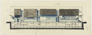
Tokyo International Forum, 1989-1996, Tokyo, Japan, East elevation of theater structures, sketch
Museum of Modern Art, New York
The Museum of Modern Art (MoMA) Collection
Japan in the Seventeenth Century: Labour Relations and Work Ethics
International Institute of Social History
Europeana API
Relief map of Japan and South East Asia from Camouflage Unit, AHQ, World War II
Alexander Turnbull Library
DigitalNZ New Zealand API
East Asia Summit or ASEAN Plus Eight – an insight into Asian regionalism from perspective of Japan...
Dolnośląska Biblioteka Cyfrowa
Europeana API
Political relations and conflict between republican China and imperial Japan, 1930-1939 [electroni...
Stanford University Libraries
Stanford Libraries SearchWorks
![Hawaii's volcanoes revealed / by Barry W. Eakins ... [et al.] ; prepared in cooperation with the Japan Marin...](https://collections.library.yale.edu/iiif/2/15249669/full/!200,200/0/default.jpg)
Hawaii's volcanoes revealed / by Barry W. Eakins ... [et al.] ; prepared in cooperation with the Japan Marin...
Yale University Library
Yale University Library Digital Collections

WAR IN THE FAR EAST: HOSTILITIES BETWEEN JAPAN AND CHINA COMMENCED LAST WEEK IN CONNECTION WITH THE QUARREL ...
Auckland Libraries
DigitalNZ New Zealand API
Last Updated: 2020-04-17
Uploaded: 2021-09-21