![[ホメロス時代のギリシアと隣接諸国]](https://rmda.kulib.kyoto-u.ac.jp/iiif/RB00023930/RB00023930_00001_0.ptif/full/200,/0/default.jpg)

ギリシア国境に隣接諸国の戦備 : 全バルカンに暗雲低迷 : 戦禍の恐れ愈よ大

ギリシアの内乱 : バルカン諸邦への影響奈何

塩飽諸島・笠岡諸島隣接海域図(香川県、広島県)

塩飽諸島・笠岡諸島隣接海域図(香川県、広島県)
塩飽諸島・笠岡諸島隣接海域図(香川県、岡山県)
塩飽諸島・笠岡諸島隣接海域図(香川県、広島県)

我国のワルポール時代

満鉄隣接線と貨物の発送 : 一月下旬の状況

反動時代接近 : 本年貿易の悲観

戦国時代の倉庫
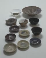
戦国時代の遺物

時代、時代の往診

プレスリリース/コロナワクチンとインフルエンザワクチンの同時接種を開始

王国時代か暗黒時代か

肥後炭層と古河 : 三池坑隣接区買収

(隣組読本)戦費と国債

日支接近と英国の勢力
![隣国土産 [その一]](https://da.lib.kobe-u.ac.jp/files/thumbnail/20000/0100382964/0100382964.jpg)
隣国土産 [その一]
![隣国土産 [その二]](https://da.lib.kobe-u.ac.jp/files/thumbnail/20000/0100382965/0100382965.jpg)
隣国土産 [その二]
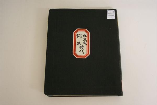
全国 銅器時代 弥生式時代

工業都市「尼崎」 : 隣接大阪と呼応し着々と発展の地歩

石油時代来る : 墨国油田と我国

在浦塩の武器が赤軍に帰せぬ様露国隣接諸国から我政府に懇請し来る

大電気時代と国策 (上・中・下)

Greece in the fifth century B.C

Europa : end of 7th century. 695

Europe in the time of Charles the great 814
![[ローマ帝国道州図]](https://rmda.kulib.kyoto-u.ac.jp/iiif/RB00023933/RB00023933_00001_0.ptif/full/200,/0/default.jpg)
[ローマ帝国道州図]

Europe in the reign of Theodoric. C.A.C. 500

Europe showing the general direction of the Barbarian inroads on the fall of the Roman Empire

Oonoshinmuranaikenchishitaezu

Asiae Nova Delineatio . .

An Improved Map of the United States By Shelton & Kensett
![Enjoying the Doll Festival: Women of the Bunkyū Era [1861-64], series Thirty-six Elegant Selections](https://honolulu.emuseum.com/internal/media/dispatcher/92098/thumbnail)
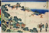
Enjoying the Doll Festival: Women of the Bunkyū Era [1861-64], series Thirty-six Elegant Selections

China and Japan

The world as known to the ancients

Carte Des Indes et de la Chine Dressee sur plusieurs Relations particulieres Rectifees par quelque...

Dominions and Dependencies of Alexander C.B.C. 323

hanging scroll; painting

滿洲歴史地理. : 第壹巻附図 : 隋代及唐初満洲図(西暦五八九年-六六八年)
「雪花月」 「吉野」(花)

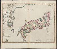
A new and accurate map of the Empire of Japan : laid down from the memoirs of the Portuguese and Dutch, and ...
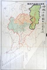
飛騨支庁管内地図(中部山岳国立公園区域図示 角竹記録)附 飛騨支庁管内里程表、各駅間粁数及三等運賃
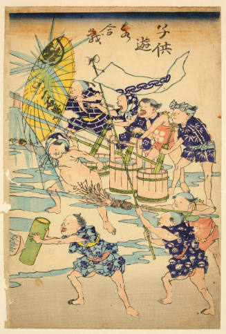
ChildrenPlaying with Water (Kodomo Asobi MIzugassen), series Brocade Pictures of Playing Children

Branch of Flowers
Iaponia Regnum

Imperii Sinarum : nova descriptio
Last Updated: 2020-04-16
Uploaded: 2021-07-27