

Japán

K.S.E.C. Társulat (Japán Színházi Központ), (Japán)

Japán Nap

Japán Nap

Japán teásdoboz

Japán fej

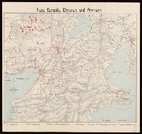
Japán – Korea

Japán figura

Japán teásdoboz

Japán jelmez

Japán nők

Japán iskola

Japán iskola

Japán iskola

Japán iskola

Japán nő

Japán tábornok

Japán Fesztivál

Japán iskola

Japán iskola

Japán mesék

Japán iskola

Japán táj

Japán fegyverletétel
Japan / by J.G. Bartholomew, F.R.G.S

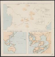
Japan and Korea / compiled and drawn in the Cartographic Section of the National Geographic Society ; James ...
Nara, Yamada, Koyasan, & environs

Eastern Archipelago : Eastern Part of Celebes

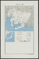
The Japanese empire : with central and southern Manchukuo (Manchuria)

Nara, Yamada, Koyasan, & environs

Japan and it's relation to the territory bordering on the Pacific ocean

Russisch-japanischer Kriegsschauplatz. Karte II, Süd-Mandschurei, Korea, Nordost-China
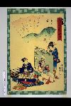
「俤けんじ五十四帖」 「薄雲」

The Islands of Japan, by James Wyld,..
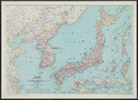
Japan and Korea / compiled and drawn in the Cartographic Section of the National Geographic Society ; James ...
![Japan and adjacent regions of Asia and the Pacific Ocean [cartographic material] / compiled and drawn in the...](https://collections.library.yale.edu/iiif/2/15509964/full/!200,200/0/default.jpg)
Japan and adjacent regions of Asia and the Pacific Ocean [cartographic material] / compiled and drawn in the...

「奥州浄瑠璃源氏十二段」 「浄瑠璃姫」
Japan, Aichi-ken
「高名美人見たて忠臣蔵」 「十二枚つゞき」「十一だんめ」

「末広五十三次」 「吉田」
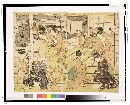
「風流子宝合」 (大からくり)

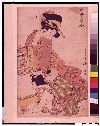
「源氏香の図」 「浮舟」

Rand, McNally & Co.'s 1904 war map of Russia and the continent of Asia

Japan, Oita-ken

「源平八嶋大合戦」
![Nihyakugojūmanbun no ichi Tōbu Chūbu "So" ryō yochizu [cartographic material]](https://stacks.stanford.edu/image/iiif/nb222jb7845%2Fnb222jb7845_00_0001/full/!200,200/0/default.jpg)
Nihyakugojūmanbun no ichi Tōbu Chūbu "So" ryō yochizu [cartographic material]

「当盛見立人形之内」 「粂の仙人」
Unzen and neighbourhood
Last Updated:
Uploaded: 2021-07-27