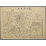


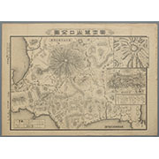
富士登山口全図
Karte vom Japanischen Reiche, nach Original-karten und astronomischen Beobachtungen der Japaner : ...

冨士山東口須走(登山案内図)

Indiae Orientalis, Insularumque Adiacentium Typus. Cum Privilegio

「下嵯峨虚空蔵法輪寺」

「安房国鋸山日本禅寺真景図」

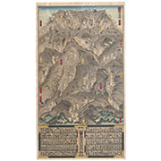
冨士山禅定図

India Orient

A New Map of Great Tartary and China, with the adjoyning Parts of Asia, Taken from Mr. De Fer's Ma...

(Covers to) Picture map of China. Designed by Frank Randolph Southard. Printed in United States of...

「上州草津温泉之全図」

China, Contains 15 Subject Provinces, including the 2 Islands of Hainan Formosa and the Tributary ...

Descriptio Hydrographica accomodata ad Battavorum navagatione Javam Insula Indiae Orientalis . . ....

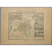
駿河国富士山表口略図

「浅草御坊御遷仏略図」

「大仏耳塚」

A pictorial map : Victory in the Pacific Designed and published by Ernest Dudley Chase of Winchest...

冨士登山口全図

Das Suedoestliche Asien oder China, Japan, und Hinter-Indien mit dem Indischen Archipelagus. (The ...

「安房国鋸山日本寺図」

Chart of the Discoveries made in 1787, in the Seas of China and Tartary by the Boussole and Astrol...

「肥前長崎丸山」

冨士登山口全図

〔冨士講社諸国商人定宿引札〕
Last Updated: 2025-07-15T01:26:19
Uploaded: 2025-07-16